The Beacon Beat
Lighthouses, descendants of the first seaside bonfires built by those who wait, always catch our eye. Admit it: You’d no more look the other way driving by a lighthouse than you would look away from the Taj Mahal or a three-legged dog.
In spite of everything nature could throw at Louisiana’s lighthouses, our coastline still boasts several survivors, well worth one big excursion or several small ones to have a look. For lagniappe, a lighthouse visit can always be combined with the pleasures of good fishing spots, seafood restaurants and water sports. Before you go, peruse the good information and photography at lighthousefriends.com (select “Louisiana”) and the pages of E’Deana Bosworth Elmer’s Lighthouses of Louisiana, available at
lighthousesoflouisiana.com.
Our “Traveler” treks rarely cross state lines, but a dramatic spot for your first glimpse of a Louisiana beacon is actually from the Texas side of the Sabine River, a stone’s throw from the Gulf. Completed in 1857, the Sabine Pass Lighthouse still rises 80 feet above Louisiana’s sandy coastline at the corner of the state, despite run-ins with many major storms and one major war.
Take Texas 87 south from Orange to Port Arthur – pausing at the Museum of the Gulf Coast (700 Procter St. in Port Arthur) to see a once- state-of-the-art Fresnel lens, this one from a now-vanished beacon called the Sabine Banks Lighthouse – and continue south on 87 to the small town of Sabine Pass.
At the intersection where 87 abruptly turns right, you’ll see a pair of historic markers recounting the Civil War battle that put this place in the history books, and the battle park itself lies just a short distance down Dowling Road from the markers. There on Sept. 8, 1863, blazing away from tiny Fort Griffin at a Union invasion fleet – four gunboats and 18 troop transports – Lt. Dick Dowling, with only 46 artillerymen and six cannons, inflicted heavy casualties, captured two gunboats plus 350 prisoners and sent the fleet retreating to Union-held New Orleans. A statue depicts Dowling wielding his firing lanyard as he gazes directly, it seems, at the lighthouse, which stands a few hundred yards down and across the river.
It’s possible to drive farther downriver for closer views – catching glimpses through the shipyards and industries that line the bank – but there’s no need. Boaters can reach the light easily from west bank ramps, and motorists can return on Texas 87 to Port Arthur and turn right on Texas 82, crossing the Sabine bridge and following Louisiana 82 a short distance to Lighthouse Road (marked by a Cheniere LNG sign). That lane leads to a locked gate adjacent to Cheniere’s office building, but that’s OK – because before you left home, you called Carolyn Thibodeaux of the Cameron Parish Tourist Commission and Cameron Preservation Association at (337) 515-7155 (author of good online lighthouse articles), who provided you with the lock’s combination.
Next comes the lighthouse itself, ultimate access blocked by a narrow waterway near its base, but you can get plenty close enough for inspection and photography. The tower’s eight great buttresses give it a distinctive look and keep it upright in the soggy soil, and it’s now weathered to a handsome brown, as seen on the U.S. stamp that honored this tower in 2009.
Standing there, it’s easy to imagine the daily arrival of Union soldiers, beaching their dinghy and climbing the abandoned tower to spy on the construction of Fort Griffin just upriver. After four years of darkness during the war, the light was relit in 1865 and served till it was abandoned in 1952. The Cameron Preservation Alliance was formed in 1999 to maintain the landmark, offering memberships and fundraising events to finance a future restoration. To join or contribute, give Carolyn Thibodeaux another call.
Heading east, our next two survivors, both long since decommissioned, are offshore lights, but one has been moved ashore for public enjoyment, and the other will very likely join it soon.
Still standing offshore, the Ship Shoal Light lies southwest of Houma and beyond the remnants of Last Island (aka Isle Dernière, the resort island smashed by the 1856 hurricane immortalized by Lafcadio Hearn’s 1888 novel, Chita). The 125-foot metal tower devoted 107 years to marking Atchafalaya Bay, from 1858
to 1965. “It’s still sturdy even after 40-odd years of abandonment,” says Mayor Louis Ratcliff of the Atchafalaya River city of Berwick, “and it’s only the funding that’s keeping us from saving it.” A state or federal grant would quickly have it barged ashore and installed at the city’s Everett S. Berry Lighthouse Park (just downriver of the Berwick-Morgan City bridges), where it would join the bay’s other surviving lighthouse, a dandy pyramidal tower called the Southwest Reef Lighthouse that was moved there in 1987.
After a new shipping channel was dredged through the shoal that gave the Ship Shoal Light its name, the Southwest Reef Light was erected in 1859 on the western section of the bisected “reef,” serving till 1916.
RIVER AND LAKE
The lights of the Mississippi’s “passes” to the Gulf of Mexico are best appreciated from a boat or hovering helicopter (call Crescent City Helicopters at (504) 914-5955 or Jesuit Bend Helicopters at (504) 912-5300), while most of Lake Pontchartrain’s lights are accessible by auto.
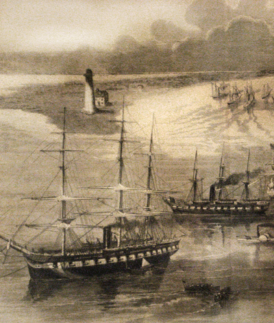
The oldest of the three lights still existing in the river’s Southwest Pass, erected in 1838, began leaning almost immediately and sinking by 1850. Its replacement was delayed by the war, however, so it was that 1838 light that witnessed Adm. David Farragut’s invasion fleet crossing the bar in March and April of 1862, intent on battling past the river forts to capture New Orleans. It was retired in 1873 and remains, although a mere shadow of its former self, visible today. The new 1873 lighthouse also survived, if barely, the hurricanes of 2005, having served until the current light was erected in 1965. That lighthouse is said by the experts at Lighthouse Friends to be the most modern in the Gulf – a sprawling two-story structure with a central tower, complete with landing pad, standing just beyond the Gulf terminus of Southwest Pass.
Historic but still functional, the Port Eads Lighthouse at the very seaward tip of South Pass was erected in 1881 and named in honor of James Eads, the self-taught engineer and river expert whose jetty system ushered the Mississippi into the modern era of shipping by creating and sustaining deeper and more stable channels. The handsome white hexagonal tower, topped with a black crow’s nest and light chamber, stands 105 feet tall and is fabricated completely of metal, including the two-story hexagonal light-keeper’s quarters built into the base.
In 1855 the easterly flowing Pass á l’Outre, having developed a deep enough channel for significant shipping, was rewarded with a light of its own, albeit a hand-me-down that had previously stood at Head of Passes. The tall iron tower witnessed Capt. David Porter’s fleet of mortar schooners entering the pass in March of 1862 to join Farragut’s armada, and it served till 1930. Rusty and now, since Katrina, without its dome, the Pass á l’Outre light
still survives.
Around Lake Pontchartrain, Katrina destroyed the beloved West Rigolets Light near old Fort Pike, the New Basin Canal Light on the New Orleans lakefront is on sabbatical, and the Pass Manchac Light at the west end of the lake is now little more than a historically important ruin. The lights that remain, however, are enough to warm the cockles of a lighthouse-lover’s heart.
The New Orleans Lakefront was once a prime party place for Orleanians, from the Milneburg resort town’s jazz halls and hotels to the casinos and dance pavilions of Spanish Fort, followed in the 20th century by Pontchartrain Beach Amusement Park. Our primary mementoes of that earlier era are the Port Pontchartrain and New Canal lighthouses, the former still standing tall and the latter temporarily (but only temporarily) down on its luck.
The first New Canal lighthouse was erected in 1838 to serve a “new canal” dug from the lake to the heart of New Orleans (today’s West End Boulevard, filled long ago). That light was followed by a one-story frame lighthouse in 1855 and finally, in 1890, by the high-stilted two-story light that was damaged by many hurricanes and finally toppled, alas, by Katrina. With its bright-colored hip roof and bright Fresnel lens, it had become not only a boon to watercraft – and not only a legend due to the daring lifesaving deeds of five or more female light-keepers – but
also a trademark-totem-logo sort of focal point for the Lakefront district.
Even before the storm, the Lake Pontchartrain Basin Foundation (guardian and benefactor of the lake) had approached the Coast Guard about leasing the light and transforming it into a museum and education center. The lease is now signed; site stabilization is complete; the wreckage is disassembled and stored; and, with $400,000 in the war chest, the structure will very likely rise again this year. Due to the extent of the damage, it will be a reconstruction rather than a mere renovation but will use, as much as possible, original materials that have been salvaged. Foundation Director Anne Rheams is now announcing a final fundraising campaign, this one for landscaping and contents acquisition that will follow in 2012.
From the New Canal site adjacent to the great old Pontchartrain Seawall and Landry’s Restaurant, follow the seawall east along Lakeshore Drive (detouring occasionally to skirt inexplicable street closures) to the University of New Orleans Research and Technology Park, which occupies UNO’s piece of the waterfront. The Technology Park’s sandy shore is the former site of Pontchartrain Beach Amusement Park, and the old masonry Port Pontchartrain Lighthouse, once surrounded there by thrill rides and concessions, still stands in a green space just north of the Lakeshore-Elysian Fields traffic circle. It’s also a landmark of 19th-century Milneburg, with its lively nightlife, Smoky Mary rail car service into New Orleans and ferries to the Northshore’s “ozone air” health spas.
Pass Manchac, Iberville’s shortcut from the upper river to the Gulf, provides a short, scenic boat ride from Middendorf’s Restaurant (Interstate 55 below Ponchatoula) through Manchac Wildlife Management Area to the remains of the Pass Manchac Lighthouse, where the pass enters Lake Pontchartrain. This was once a marvelous masonry marriage of a lighthouse and a two-story light-keeper’s residence, erected in 1857 to replace older lights, but sinkage and intentional demolition of the residence (a dangerous enticement to vagrants) have spared little more than the base of the tower, cared for by the Lighthouse Committee of the Lake Maurepas Society.
On the Pontchartrain Northshore, just west of the mouth of the Tchefuncte River, stands an 1868 beauty that’s the favorite of many, the Tchefuncte Lighthouse, erected to replace an 1838 light serving steam-ferry passenger services from New Orleans and the river’s small industries and shipyards (where ships for the Confederacy were launched before the fall of New Orleans). The tower, always well-painted, is still high and dry despite recent encroachment by the lake, but it’s no longer open for exploration due to deterioration of its interior stairway.
After the light was automated in 1952, the keeper’s dwelling was moved into Madisonville, where it stands behind the Lake Pontchartrain Basin Maritime Museum (site of the old Jahncke Shipyard) at 133 Mabel Drive. Main Street follows the river almost to the lake, ending at a parking lot/boat launch that provides a clear view of the lighthouse. Afterward, visit the Madisonville Museum (201 Cedar St., (985) 845-2100) to see a printed history of the light plus vintage photos of the lighthouse and its bell tower, which, according to curator Virginia Stanga, could become even more important than the light in a Pontchartrain fog.